Seeing the Big Picture
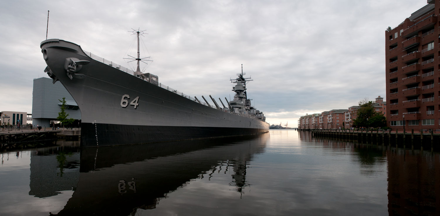
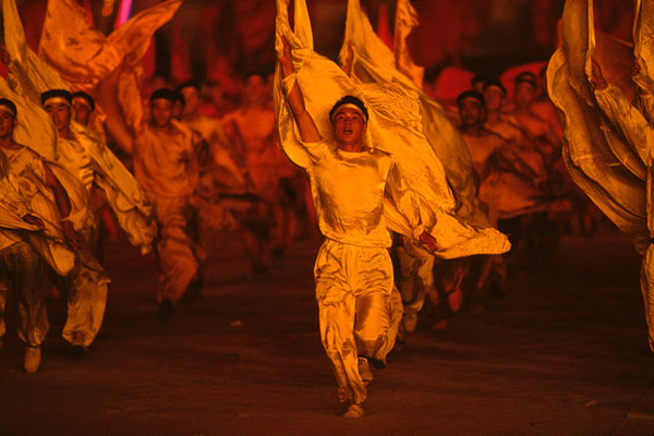
A panoramic photo of a World War II battleship, Norfolk, Virginia.
Photos by Forrest Anderson
We are living in the Great Age of Panoramas, when super wide angle photographs are an everyday part of our lives.
From Google Map’s Street View and the wide view of our car’s backup camera to the bizarre wide x-rays that dentists take of our mouths and the panning we see constantly in movies, the panoramic photo has come into its own.
The ability to create panoramic photos on smartphones is within reach of anyone who uses their phone camera. Smartphone panoramas are so easy to take and so high quality that they have become a standard tool for even professional photographers.
Panoramic photos are unexcelled in their ability to convey important messages about very large environments or objects.
Here are some of the ways my husband and I use panoramas in our professional photography:
Landscape photography. This is the most common use of panoramas for most people. There is no better way to photograph a mountain, valley or large body of water than a panorama.
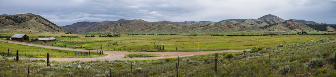
This landscape photo is a panorama of the Powderhorn valley, a ranching community in western Colorado.
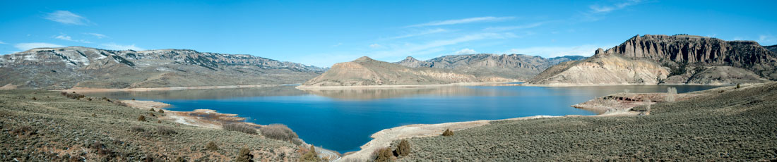
Environmental photos. We shoot a lot of these, and panoramas are one of the best ways to convey important information about the environment. No environmental issue is more important than water and its associated hydroelectric facilities. This photo shows water levels on the Blue Mesa Reservoir in Colorado.
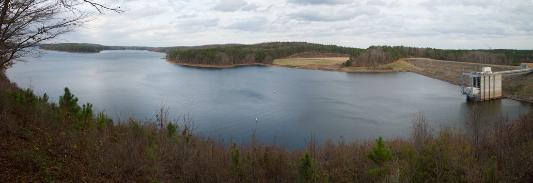
The photo below, shot for a clean energy organization, shows hydroelectric facilities on Jordan Lake, North Carolina.
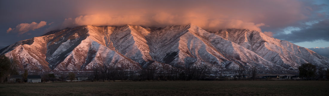
Panoramic photographs are one of the best ways to record weather patterns, as shown in this photo of the mountains east of Mapleton, Utah
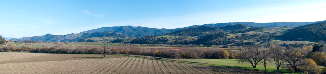
Panoramas work well for agricultural photos. This photo is of farmland in the Santa Ynez Valley, California.
Cityscapes. This panorama was created from a series of photos taken in the 1990s in Beijing, China. Combined with modern images, this type of panorama can show the change in a city over time.
.jpg)
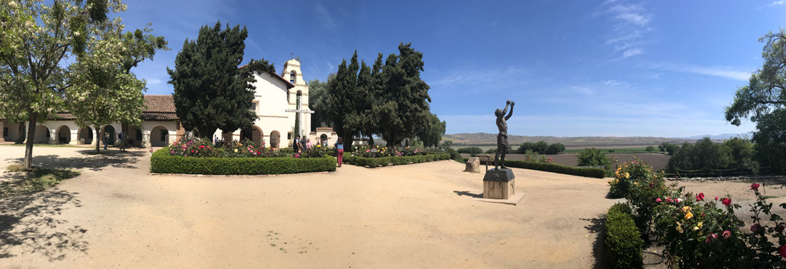
Large geographic or historical sites such as town squares can be shown with panorama photos. The photo below shows the San Juan Bautista Mission in California, with its accompanying town plaza and, to the right, where the original El Camino Real went past the mission.
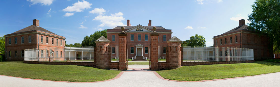
Panoramas are a great way to capture the sweeping nature of historic estates and plantations. Below, Tryon Palace, New Bern, North Carolina.
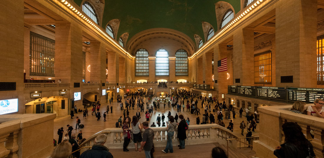
Panoramas are often the only way to capture the interiors of large buildings. The panorama below is of the interior of Grand Central Station in New York City.
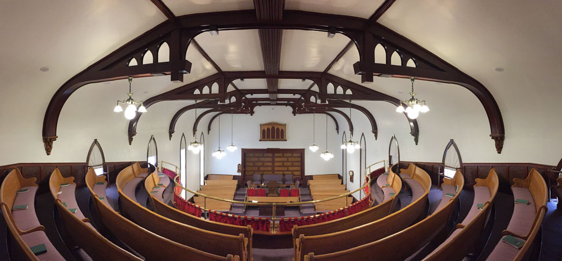
Below, the interior of a historic church in Spring City, Utah.
Events with large groups of people such as concerts. As regular cameras sometimes aren’t allowed into such venues because they make noise, phone panoramas can be a quiet alternative. The photo below was of a Christmas concert in which a choir and orchestra performed and the audience sang along. A panorama was the only way to capture all of the participants.
.jpg)
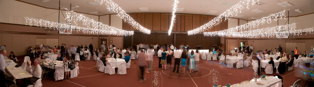
Panoramas can be great ways to capture the overall scene at events such as weddings, below.
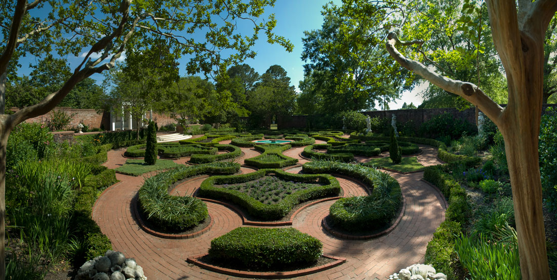
Gardens are difficult subjects to photograph, and panoramas can be one of the best ways to do so. Below, the historic garden at Tryon Palace, New Bern, North Carolina.
Panoramas also work well for large objects such as ships (see the top photo), docks or large machinery.
The built-in software in smartphones makes creating panoramas easy because it automatically creates images that you can quickly edit and enhance. When you are shooting hundreds of photos on a tight schedule, this processing speed makes it feasible to take panoramas.
The iPhone camera produces a high-quality panorama that prints beautifully, so there is no reason to use more expensive equipment for panoramas.
It can be hard to hold a camera steady for panoramas, and phones have built-in optical stabilization that means they do so well with hand-held panoramic photography that we typically don’t use a tripod. This comes in handy in venues where no tripods or standard cameras are allowed. If you’re struggling to hold your phone steady and you don’t have such restrictions you can use an iPhone tripod and mount.
Tips for shooting panoramas with your smart phone:
- Clean off the lens on your phone before shooting.
- Moving people, animals or other objects can come out distorted in weird ways in panoramas, so do some tests. We try to shoot panoramas of crowded locations early or late in the day when they are less crowded.
- Panoramas also distort some horizontal lines, such as a street in front of a group of buildings, so it’s a good idea to do some tests.
The desire to see and understand a broader view of the world around us is an innate human trait that has fed visual representations of the world for thousands of years. Rock paintings, murals in ancient locations such as Pompeii, maps, scroll and accordion paintings and relief sculptures on monuments such as the Parthenon and the Trajan column all fed into this quest.
In the 18th century, English painter Robert Barker gave this phenomenon the name “panorama” from the Greek words for “all” and “sight.” Barker used the term to describe his sweeping paintings of Edinburgh and London. Barker created a 360-degree panoramic painting that was exhibited on a cylindrical surface. He built a rotunda for viewing the painting that attracted visitors for 70 years.
The term was adopted shortly after the 1839 invention of photography for wide angle photos made by combining single images into one long one. Panoramas are so pervasive in the modern world that we have adopted the term “panoramic view” to describe not just wide images, but general large-scale groupings of knowledge.
During the mid- and late-19th century, panoramic paintings were popular ways to represent landscapes, topography and historical events such as the Civil War Battle of Atlanta. Audiences flocked to see 360-degree paintings that gave them the impression of being immersed in a new environment. An offshoot was smaller paintings that were on a large scale onto walls of rotundas.
As the scenes moved past viewers, a narrator would describe them. The shows were so popular that they enriched showmen such as John Banvard, whose panorama of a trip on the Mississippi River financed his immense imitation of Windsor Castle on Long Island, New York.
Moving panoramas displayed grand ceremonies and processions such as British King George IV’s coronation. Other popular themes were travel to India, New Zealand, the Arctic, Niagara Falls and out west on railroads as the United States expanded. The panoramas educated people about the expansion of the British Empire and the United States. Few have survived, and they are too fragile to show in motion today.
The technology was adopted for backgrounds in theater productions, making panoramas an early predecessor of cinema. Each end of moving panoramas were rolled onto long continuous painted canvas scenes around two large spool mechanisms. The scrolls were turned so that the canvas scrolled across the back of a stage. In front of them were placed boats, horses, vehicles and other scenes that hid the mechanisms. When a painting was scrolled across the stage, it gave the impression that the vehicles and animals were moving. Music, sound effects, lighting and puffs of smoke and rippling cloth used to imitate waves added to the experience.
The main action in the 1899 play Ben-Hur was a live chariot race using real horses and chariots set against a moving panorama. Horses galloped toward the audience, secured by invisible steel cable traces and running on treadmills while electric rubber rollers spun the chariot wheels. A vast backdrop revolved in the opposite direction to create an illusion of speed, while fans created clouds of dust. The play inspired the live chariot race in the 1959 film adaptation of Ben Hur.
An extension of moving panoramas into motion pictures was pioneered with the invention of the Cinéorama, an amusement ride at the 1900 Paris Exposition that features images projected on ten synchronized projecters. These evolved into IMAX and Circle-Vision 360°.
Panoramic cameras were invented that used curved film holders and clockworks to rotate multiple lenses, enabling the creation of images that took in almost 180 degrees. The camera industry still produces new panoramic cameras, panning tripod heads and software to facilitate the creation of panoramas. Most cameras are based on the idea of piecing together a sequence of photos into a single image.
George Bernard, a photographer for the Union Army during the Civil War, used this method to produce panoramas of fortifications and terrain that generals and army engineers used to fight the war.
Panoramic cameras became invaluable in surveying and cartography. From 1911 to 1932, the United States Geological Survey (USGS) created about 5,000 panoramic photos in the Alaska Territory as aids in topographic surveying. Some of the photos were combined to create 360-degree panoramas. This experience in turn led to the development of aerial photography.
Early films were called “moving pictures,” and the concept of projecting changing locations on a rear window of a car to convey motion in films emerged from the moving panorama. Long before computers, panoramas were stitched together to provide motion and special effects in film, which itself was the projection of multiple still images in succession to provide visual animation.
During the 1970s and 1980s, multi-image slide presentations used multiple slides to create panoramas, projecting them with synchronization to control the advance and fading of the slides and with accompanying audio tracks. Cutting and dissolving between slides could generate animation effects. Digital photography took off in the 1990s and greatly simplified this process, allowing images to be automatically stitched together with software to show broad views and time lapses.
Panoramic movies for use in theme parks, museums and at world fairs take advantage of digital automation to create sophisticated immersive experiences for 360° theaters and adventure rides. They combine panoramic photography with audio effects, shaking or moving of seats and entire rooms, strategically sprayed water and the circulation of air that is scented, cooled or warmed.
Google Street View uses a panoramic camera mounted on a vehicle and combined into panoramic images, a technique called route panoramas. The images are used for both navigating and referencing locations. Google Street View’s interactive panoramas are created in more than 80 countries from cameras mounted on cars, tricycles, boats, snowmobiles and underwater apparatus as well as on backpacks that can be carried on foot.
Street View began in 2001 with a Google-sponsored Stanford University research project. Complaints about privacy led to the addition of face blurring technology in 2008. Google added business interior views in 2013. Since then, Google has steadily added features.
Because panoramic photos are produced in segments photographed sequentially, the passage of time is inherent in them and they can be used to create time lapses. This has led to a variety of applications.
Panorama portraits show multiple versions of a person in a single wide environment. Panoramic photography is used by 3D artists to photograph realistic textures and elements of faces that can be placed on virtual 3D faces to create highly realistic characters.
Panoramas are used extensively in science to show changes in environments over time. They are a key tool for climate change scientists who track changes in glaciers, animal habitat and water resources over time.
GigaPan, a spinoff of a collaboration between NASA and Carnegie Mellon University, markets relatively inexpensive camera mounts that enable scientists and others to take “gigapixel” images composed of many smaller images. The result is a huge high-definition panorama made up of millions of pixels which the viewer can explore and zoom in on. It is literally a way to see both the forest and the trees.
GigaPan images have been used for a wide variety of uses:
- Monitoring ecosystems. Defenders of Wildlife has used GigaPan to monitor jaguar habitat in the Northern Jaguar Reserve in Sonora, Mexico. Australian scientists have used GigaPan to document the effects of climate change on sea mammal and seabird populations, monitoring nest locations, chick presence and adult arrival times in colonies. Underwater photographers have used Gigapan to understand environmental changes in coral reefs and other underwater populations. Gigapan has been used to explore the impact of shale drilling on water quality. Gigapan has been used for cosmological simulations, archeaological documentation and preservation, studies of sedimentary rock layers and zoology. Ancient petroglyphs on remote cliffs have been photographed and studied using GigaPan. The technology helps beekeepers see the overall picture of a beehive and zoom in on individual cells to detect disease.
- For North Carolina State University, GigaPan has been explored as a way to share the university’s insect museum’s collection of 1.5 million insects with entomologists worldwide. GigaPan photos can be taken of insect drawers, each of which could have 50 large beetles or thousands of tiny insects. The drawers are snapshots of what insects were present in North Carolina going back to the 1800s, so they help to track insect conditions as the state has urbanized.
- Forest ecologists have used GigaPan to determine the number of trees in stands all over the world, a strategy which can help track changes and be used to restore historic forests. Invasive plants can be identified in the photos so the extent of the invasion can be determined. Combined with time-lapse photography, the panoramas can track subsequent spread. Time-lapse panoramic photography also is used to track plant behavior and the effect on plants of environmental changes in habitat. Rangeland ecologists can zoom in on GigaPan panoramas to study individual plants, animals or features. They can use the photos to determine the number of elk in herds and their condition.
- Solar panels have powered the use of time-lapse panoramic photos taken every two hours for a month of an Arizona grassland to record the greening of the grassland in response to rain. Viewers can zoom in on an individual cactus to see its response to rain. Panoramic photography can be used in this way over years to record an area’s recovery from a fire or for hours to photograph a flash flood. Panoramic photography has advanced analyses of landscape change, precipitation patterns and the effects of grazing.
- GigaPan is an excellent mapping tool because the information in GigaPan photos can be turned into 2-D maps easily.
Because the photos are posted on www.gigapan.org, they facilitate collaboration between researchers.
GigaPan Time Machine, an offshoot of GigaPan, creates time-lapse movies in which the viewer can zoom in or out to watch different stories play out on small scales across a larger panoramic image.
An example is a daylong view of the sun from NASA's Solar Dynamics Observatory compressed into 140 seconds. That satellite constantly watches and photographs the sun. Another example is a time-lapse of oceanic chlorophyll concentrations between 2002 and 2011, as monitored by NASA's Aqua satellite. It enables a user to watch seasonal shifts on the global level or occasional chlorophyll flare-ups in the Gulf of Mexico from the runoff of agricultural fertilizer and other contaminants.
In astrophysics, 360° spherical panoramas with astrophysical data have been combined with virtual reality and augmented reality to allow scientists to be immersed in data-rich 3D environments using headgear. Scientists can be stationary in the middle of the celestial sphere as they move through a 3D data set, looking around in any direction.
The European Organization for Nuclear Research (CERN) particle accelerator complex uses 360-degree tools to provide panoramic data of their facilities to all users during periods with no access or during shutdowns. NASA pioneered 360-degree panoramic technology in their Mars Rover InSight missions. Panoramic cameras are used extensively alongside other cameras on NASA space flights.
Virtual tours are based on 360-degree panoramas. They are used to visualize art and architecture, record endangered historical sites and provide virtual on-line museums and databases. Panoramic photography is used in news reporting, live sports, remote team collaboration, and other remote communication. It is used to provide virtual tours of houses and commercial buildings for sale.
In the construction industry, 360-degree panoramas of virtual jobsites are used with interactive links to movies, drawings and animations to help construction students learn about construction processes. They are used to communicate construction needs to subcontractors and to document potential issues and hazards that arise during construction as well as train workers in safety.
Panoramic photography is used along with underwater drones to investigate features in lakes and the ocean.
During and after World War II, super wide angle panorama cameras were developed for mapping and reconnaissance. In the 1950s and 1960s, scanning cameras were developed that were precursors of later satellite scanners. Panorama and wide-angle cameras on public places and in the interior of buildings have become common for security reasons. The use of these cameras for surveillance has raised privacy issues, as high-resolution panoramas are used for surveillance of private citizens.
Photogrammetric panorama processing, the use of photography in surveying and mapping to measure distances between objects, is used for 3D reconstruction and documentation of architectural and historical sites and objects.
The Catlin Seaview Survey created a database of underwater images that documents the health of the Great Barrier Reef. It involved more than 100,000 360-degree panoramic images along the length of the reef, some 2,300 kilometers. Other coastlines have been documented the same way to make up an online database called the Reef Record. The information helps understand and track the effect of changing climate and pollution on coral and other marine life.
Panoramic dental x-rays, which capture the entire mouth in one image, are an important diagnostic tool used to plan treatment for dentures, braces, extractions and implants as well as revealing tumors, diseases, jaw disorders and sinusitis.
Panoramas are so important to visual imagery that there is an International Panorama Council, a nongovernmental global network of museum directors, managers, artists, restorers and historians who deal with panoramas. The council is involved in restoring, researching, financing, exhibiting and marketing panoramas and their related art forms. The council maintains a database of panoramas, moving panoramas, large-scale dioramas, and other related forms.
Check out these related items

Making the Invisible Visible
The field of data-based infographics is helping the world see, understand and respond to the invisible threat of the pandemic.